Tweed Heads South levee and drainage study

 What we're doing
Tweed Shire Council, with support from the NSW Department of Planning and Environment (DPE), has engaged flood specialists Catchment Simulation Solutions to prepare a detailed levee and drainage study for Tweed Heads South and Banora Point.
The study follows the significant flooding events of March 2017 and February/March 2022, which caused widespread damage and disruption to homes, businesses, industry and infrastructure. It builds on the Tweed Valley Floodplain Risk Management Study (2014) and provides a more detailed local understanding of flood behaviour. It considers drainage performance behind the levee as well as the potential consequences of levee overtopping, storm surge, overland flooding and combinations of these events.
The draft report is on public exhibition from Tuesday 9 September to Sunday 26 October 2025, alongside proposed mitigation measures. This is your opportunity to review the findings and provide feedback before the study is finalised.
This project is supported with funding from the NSW Government’s Floodplain Management Grants Program.
Draft report and supporting documents
Reviewing the draft report and proposed mitigation measure first will help you give feedback that reflects your experience and can be properly considered in the final recommendations. Your participation is important as it will help Council and its consultants finalise the study and ensure the recommendations reflect local knowledge and community priorities.
To help you provide informed submissions, this page also includes:
- what we’ve done to date, including how the community helped shape the draft report
- what we are recommending, with a summary of the proposed mitigation options.
- details of the community information sessions and how to register
- how to have your say and provide feedback before the exhibition closes.
The draft report and supporting documents are available to download below. Files are provided separately due to size:
- Draft Tweed levee and drainage study report
- Appendices
- Figures 1–11
- Figures 12–22
- Figures 23–30
- Figures 31–38
- Figures 39–55
What we’ve done to date
 June 2005 flood: Machinery Drive, Tweed Heads SouthThank you to all community members who participated and contributed to the initial consultation. Your input was invaluable in helping us build and calibrate a detailed flood model of the river and stormwater drainage system across Tweed Heads South and Banora Point.
The first stage of consultation took place in July/August 2023. More than 230 residents and businesses shared their flood records, photographs, videos and experiences. This information, combined with surveyed flood marks, was used to validate the model and ensure it reflects both technical data and lived community experience.
Community input also helped identify the types of flood risk management measures most likely to be supported. To gather this feedback, we:
- held online and in person drop in sessions
- distributed flyers across Tweed Heads South and Banora Point
- collected submissions via this webpage, including photos and records
- provided printable forms for hard copy submissions
- promoted the project through Council’s channels, including social media, media releases and website updates.
This strong level of participation gave us valuable local knowledge, which has shaped the draft report now on exhibition.
We developed a detailed flood model of the river and stormwater drainage system across Tweed Heads South and Banora Point, calibrated using rain and river gauge data, historic flood marks surveyed by Council and insights from initial community survey responses. The model was then used to simulate different types of flooding including riverine, local stormwater and coastal storm surges. These simulations helped us understand the potential impacts of major flood events, including financial damage, transport disruptions, risks to life, and the effects of climate change and levee failure.
From this assessment, a range of structural and non-structural flood risk management measures were identified and evaluated (e.g. levee and stormwater upgrades, community education initiatives and flood warning system improvements). Each measure was assessed against cost, effectiveness, emergency response benefits, community support and environmental impacts, leading to a prioritised set of recommended actions.
The outcomes of this work are documented in the draft levee and drainage study report, supported by a suite of mapping compendium illustrating the extent and nature of flooding across the study area. The draft report, which also outlines the recommended flood risk management measures, has been submitted to the Tweed Floodplain Management Committee and Council ahead of public exhibition.
Read more about the study background and local flood types.
What we're recommending
 June 2005 flood: Twin Towns Juniors, Fraser Drive and Leisure Drive, Banora Point
The draft report outlines a mix of structural and non-structural flood mitigation options to help reduce future flood risk. The survey gives you the opportunity to have your say on these proposed measures, letting us know which options you support and raising any issues or opportunities we should consider.
To help you visualise:
- watch the presentation video for an overview of the Tweed Heads South Levee and Drainage Study
- watch the animation to see the difference in flood impacts during a 1% annual exceedance probability (AEP) event – with and without the proposed levee and learn how it could help reduce flood risk.
- view the map of recommended structural options, highlighting where structural changes are being considered to improve flood protection.
Structural options
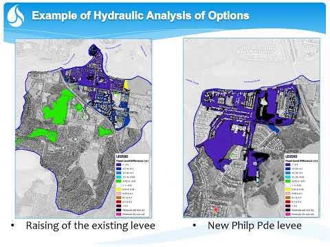
- Increase height of existing levee: Raise the existing levee around Tweed Heads South to provide increased protection from riverine and storm surge events.
- Philp Parade levee: Create a new levee alongside Philp Parade to afford protection to north-western sections of Tweed Heads South. If you live or own property in this area – including Philp Parade, Kirkwood Road West, Acacia Street, James Road or Dry Dock Road – we’d love you to come along to the dedicated community information session. You can check the map to see if your property is in the area that may benefit from the proposed levee.
- Shallow Bay Drive levee: Construct a new levee near the corner of Shallow Bay Drive and Eastlakes Drive to provide additional protection from inundation from the Tweed River.
- Minjungbal Drive pump: Construct a new pump near the intersection of Minjungbal Drive and Heffron Street to assist in draining the area behind the existing levee, as well as the commercial area near Minjungbal Drive.
- Cominan Avenue stormwater upgrade: Upgrade the stormwater system along Cominan Avenue and part of Toolona Avenue to reduce overland flow.
- Minjungbal Drive roundabout stormwater upgrade: Upgrade the stormwater system and/or raise the road to assist evacuation and emergency response operations through this busy intersection.
Non-structural options
- Changes to Development Control Plan (DCP): Update the DCP to assist in making new development more resilient to flooding.
- Updates to guide future development: A range of suggestions aimed at reducing future flood risk, including progressive filling of habitable areas and roads and elevating the stormwater system to address sea level rise.
- General community education strategy: Education to avoid dangerous behaviours (e.g. driving through floodwater) and promote evacuation during large floods.
- NSW State Emergency Service (SES) local flood plan updates: Updates to local flood planning informed by flood intelligence produced as part of this study.
- Private flood plans: Property level plans for residential and commercial sites to outline what to do before, during and after a flood to reduce damage and risk to life.
- Kirkwood Road extension: New east–west road between Fraser Drive (near Acacia Street) and the Pacific Motorway (M1) to assist evacuation from the north-western sections of Tweed Heads South.
- Flood warning system: Include Tweed Heads/Tweed Heads South as a new flood forecast location.
Community information sessions
We’re hosting a series of information sessions where you can learn more about the draft report, including the updated flood mapping, risk assessments and proposed mitigation options.
👉 Registration is essential for all sessions. Please register for your preferred session.
Online session
The online session was held in a presentation style format, which provided an overview of the draft report and the proposed mitigation options. A Q&A session followed, giving attendees the chance to ask questions directly and provide feedback. If you missed the session, you can still watch the recording.
💻 Wednesday 24 September 2025 | 10 – 11 am (via Microsoft Teams – link provided after registration)
In person sessions
The in person sessions are drop in style, so you can come at a time that suits you during the advertised hours. Council staff and project specialists will be available to explain the draft report, talk you through the proposed options and answer your questions one-on-one.
📍 Wednesday 1 October 2025
- Afternoon drop in session | 1:30 – 3:30 pm | Banora Point Community Centre
- Evening drop in session | 5:30 – 7:30 pm | Tweed Heads South Community Centre
📍 Tuesday 14 October 2025
- Drop in session will focus on the proposed Philp Parade levee | 4 – 7 pm | Pacific Coast Christian School
Can't attend?
Don’t worry, you can still watch the presentation video or the recording of the online information session for an overview of the Tweed Heads South Levee and Drainage Study.
Have your say
The draft report explains the newest flood modelling, risk assessments and the thinking behind each proposed option. It was developed in consultation with key stakeholders and contains important information that will help you give informed feedback.
Please read the draft report and proposed mitigation options before completing the survey so your input can be properly considered in the final recommendations.
Share your feedback by Sunday 26 October 2025 in one of the following ways:
- Complete the online survey after reviewing the draft report and summary of options
- Email: tsc@tweed.nsw.gov.au | Subject: Tweed Heads South Levee and Drainage Study
- Mail: General Manager, Tweed Shire Council, PO Box 816, Murwillumbah NSW 2484 | Subject: Tweed Heads South Levee and Drainage Study
More information
If you have any questions or would like to provide additional information, please contact:
Leon McLean
Engineer – Flood and Stormwater
Email: tsc@tweed.nsw.gov.au(External link)
Phone: 02 6670 2400
Videos
-
 This is a recording of the online session held on Wednesday 24 September 2025, in a presentation style format, providing an overview of the draft report and the proposed mitigation options.
-
 This presentation video will give you an overview of the Tweed Heads South Levee and Drainage Study.
-
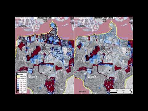 This animation shows what flooding could look like in Tweed Heads during a 1% annual exceedance probability (AEP) flood – with and without a proposed levee. It helps explain how the levee could protect homes and businesses. Watch the animation and share your thoughts during the public exhibition.


Who's listening
-
Phone 02 6670 2400 Email tsc@tweed.nsw.gov.au -

Phone 02 8355 5501 Email david.tetley@csse.com.au -
Phone 02 6670 2400 Email tsc@tweed.nsw.gov.au

CSP
Connection to Council's Community Strategic Plan:
