Burringbar and Crabbes Creeks Flash Flood Alert
Thank you for your feedback
The survey on the Burringbar and Crabbes Creeks Flash Flood Alert system closed on Sunday 15 June 2025.
Thank you to everyone who registered for the service and shared their feedback. Your input will help inform whether the alert system should be continued, adjusted, expanded or discontinued.
While the survey is now closed, the flash flood alert system remains active as we complete our review. Community feedback will be considered alongside a technical assessment of the system’s performance. A recommendation will be presented to the Floodplain Management Advisory Committee in the coming months.
We appreciate your input and your support in helping improve flood preparedness and community safety.
Learn more about the project
The flash flood alert system was developed to provide timely warnings for flash flooding in the Burringbar Creek, Mooball Creek and Crabbes Creek areas — locations known to flood with little or no warning.
The system uses a combination of local rain and stream gauges, along with Bureau of Meteorology prediction tools, to forecast potential flash flooding. When certain thresholds are met, alerts are distributed via SMS, email or recorded voice calls to registered users.
Learn more about:
-
System based on community insights
Thanks for participating!

Tweed Shire Council, with assistance from NSW State Emergency Service (SES) and other government agencies, developed a flash flood alert system that reflects the community's needs.
Thanks to those who participated in our early community engagement, the flash flood alert system for the Burringbar Creek, Mooball Creek and Crabbes Creek areas is currently being trialled.
Alerts are distributed via SMS, email and recorded voice calls (landline) – these options were selected based on the community’s preference.
It’s important to note that this service does not replace but complements advice from the NSW State Emergency Service (SES), Bureau of Meteorology (BOM) and other leading authorities during flood events. Please continue to follow directions from these agencies.
Residents can still register to receive free automated flood alerts via SMS, email or voice call for the Burringbar, Mooball and Crabbes Creeks areas.
Initial design input
In 2021, the community was asked to complete a survey to help design the flash flood alert system. Contributions closed at 4 pm on Wednesday 3 March 2021. Feedback received during this stage helped shape the system’s design, including preferred alert channels and thresholds for different flood levels.
The community provided input on the following key questions:
- What are your biggest flood concerns?
- What flood impacts do you need to know about in advance (e.g. road access closing)?
- How much warning time do you need to prepare your home?
- How much warning time do you need to evacuate?
- How would you like to receive alerts (SMS, phone, siren etc)?
- What level of flooding do you consider minor/moderate/major at your location?
Evaluation survey now closed
A follow-up survey was conducted to evaluate the effectiveness of the trial alert system. This survey has now closed on Sunday 15 June 2025. Community feedback from the evaluation phase will be reviewed alongside a technical assessment of the system to help determine its future.
Learn more about the alert system or explore the project background.
More information
Learn more about the alert system or explore the project background.
-
Project background
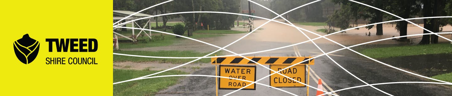
Previous flood risk management studies have shown that the Burringbar, Mooball and Crabbes creeks areas are subject to flash flooding with little to no warning. The March 2017 flood event proved this with many people caught unawares by flooding.
Funded under the NSW and Commonwealth Government's Natural Disaster Resilience Program, the flash flood alert system enables residents to prepare their properties and/or evacuate to a safe place prior to the onset of flooding to avoid being caught out by flooding in the middle of the night.
Flooding in Burringbar, Mooball and Crabbes Creeks
Many areas of Burringbar and Crabbes Creek catchments are known to flood. Key areas of concern include:
- Dignan Street/Hunter Street/Tweed Valley Way areas
- Mooball (both north and south of the railway embankment)
- Crabbes Creek Village
- various rural road crossings (e.g. Greenvale Court culvert)
View the map of flooding areas.
A key consideration for flooding in the area is the lack of warning time. Floods can occur within a few hours of heavy rainfall leaving little or no time for residents to prepare or evacuate.
The small Burringbar Creek and Crabbes creeks catchments are not covered by the Bureau of Meteorology flood warnings as the time between rainfall and flooding is too short. Therefore, Council developed an automated flash flood alert system to provide advanced notice of approaching floods to local residents.
2017 flood damage to Shackles Bridge in Burringbar (image courtesy of Serena V Dolinska)
Learn more
Community feedback shaped the development of the flood alert system – read more.
The flash flood alert system has two main components: flood forecasting and alert distribution – learn more.
-
About the system
The flash flood alert system has two main components: flood forecasting and alert distribution.
The flood forecasting system involves a cloud-based computer system, running continuously, that accepts data from the local rain and stream gauges and combines this with various Bureau of Meteorology prediction products to forecast flooding into the near future.
The forecasting system is being monitored at all times. When predictions exceed certain thresholds an alert will be distributed to the community, SES and Council advising of approaching flooding, the expected timeframe and magnitude at key locations.
For context, below are links to similar flood alert systems other councils are already using:
- City of Parramatta flood warning service
- City of Newcastle flood alert service
- Early Warning Network (EWN) flood/rainfall monitoring and alert
Discover how community consultation helped shape the flood alert system or explore the project background.


More information
-
 Have your say on the future of this service by Sunday 15 June 2025
-
Register to received flash flood alerts
-
Early stage community consultation
-
About the flash flood alert system
-
Project background
-
Maps of flooding areas - Upper coastal creek - Burringbar, Mooball and Crabbes Creek (12.4 MB) (pdf)
-
Australian Disaster Resilience Handbook Collection - Flood Warning - Manual 21
Who's listening
-
Phone 02 6670 2400 Email tsc@tweed.nsw.gov.au -

Phone 02 6670 2400 Email tsc@tweed.nsw.gov.au